

.

.


Main photo gallerys are below Information.
MOLE CREEK
Chudleigh, Lobster Falls, King Solomon's Cave, Parons Track, Alum Cliff & Trowunna
SMALL PHOTO & INFORMATION PAGE
MOLE CREEK is a hamlet in a mountain valley in the northern part of central Tasmania. It has some great, easy to access attractions, including caves, a wildlife park, plus excellent access to the Great Western Tier Mountains for intrepid bush walkers. There are some facilities and some accommodation at Mole Creek. The attractions include the:
-
TROWUNNA Wildlife Park is east of Mole Creek,
-
KING SOLOMONS Cave is west of Mole Creek
-
MARAKOOPA Caves is west of Mole Creek,
-
ALUM CLIFFS is east of Mole Creek,
-
CHUDLEIGH HONEY FARM is east of Mole Creek.
-
PARSONS TRACK is south of Chudleigh
Mole Creek is located west of Deloraine and south of Sheffield. From MOLE CREEK you are 30 minutes from SHEFFIELD, DEVILS GULLET, Mt JERUSALEM, Mt ROLAND and DELORAINE. Nearby places are described in the CENTRAL MOUNTAINS REGION page.
View Region Central Mountains of Tasmania in a larger map
FACILITIES: There are a small number of shops, a hotel and a cafe and a petrol station at Mole Creek. There is the Honey Shop at Chudleigh. There is accommodation at MOLE CREEK.
TOURIST general information is at 98 Emu Bay Rd, Deloraine. The telephone number is Deloraine (03) 6362 3471 or the internet contact is www.greatwesterntiers.net.au
For information on the Mole Creek Karst National Park telephone (03) 6363 5182 Note the following contact numbers.
SIGHTS: Mole Creek is hamlet on the edge of the Great Western Tier Mountains, which tower over the hamlet. Mole Creek is a popular dormitory for people visiting the Tiers. It has a number of first class attractions nearby. These include the;
-
TROWUNNA Wildlife Park is where you can see a wide variety of Tasmanian animals, including devils, quolls, kangaroos, eagles and other birds. For information telephone (03) 6363 6162 or 0418 177 518 Trowunna is located east of Mole Creek. Look for the large devil sculpture. The Internet contact is www.trowunna.com.au/
-
PEPPERBERRY CAFE at Mole Creek offers great accommodation and dining. The telephone is 03 63631399 or www.molecreekguesthouse.com.au
-
CHUDLEIGH HONEY Farm is a unique honey tasting venue, restaurant and shop. The telephone number is (03) 6363 6160 or the Internet contact is www.thehoneyfarm.com.au Chudleigh is located just east of Mole Creek.
-
LOBSTER FALLS is a relatively east to reach series of cascades near Chudleigh. Access is from Mole Creek Road.
-
KING SOLOMON'S Cave is a very interesting limestone cave. The telephone number is (03) 6363 5152. It is located west of Mole Creek.
-
MARAKOOPA Cave is also a great limestone cave. Their telephone number is (03) 6363 5182. It is located south west of Mole Creek.
-
ALUM Cliff is a very strange colored cliff. It is just east of Mole Creek on a well signed turnoff to the North of B12.
ROUTE: Turn off the A1 Bass Highway at Deloraine and drive west on B51 and you will soon reach Mole Creek.
The DEVILS GULLET, Mt JERUSALEM and CRADLE MOUNTAIN are all west of Mole Creek and can be accessed from roads continuous to Road B51, which Mole Creek is located on.
To LARGER MOLE CREEK PHOTOS
- Trowunna
- MOLE CREEK
- Alum Cliff
- Chudleigh
- Solomon's
- Parsons
- Lobster

1/ The Trowunna Wildlife Park is east of Mole Creek in northern central Tasmania. The entrance is marked by this devil sculpture, which makes it easy to find.

2/ The Tasmanian devil is a small carnivore about the size of a cat. Trowunna has a successful captive breeding program to help save them from the Devil Facial Tumour Disease.

3/ Devils feed by tearing a carcass to pieces. They are very aggressive to each other. Feeding time is an interesting event at Trowunna.

4/ This ranger at Trowunna knew how to calm devils. You are strongly advised not to attempt to touch devils. They are aggressive and have a very powerful bite.

5/ This kangaroos at Trowunna was friendly, but it is a mistake to try to touch them, as they have a vicious kick.

6/ Kangaroos like to stay together as a mob, as this keeps them safe from predators. There was a large mob of kangaroos at Trowunna.

7/ The quoll is a tree living carnivore about the size of a cat. Here you see one eating a rabbit. Like the devil, it has a powerful. You should never attempt to touch one.

8/ Quolls are inquisitive creatures, who are continuously sniffing the air for scents like the devils do. They were an interesting animal to watch at Trowunna.

9/This photo shows a quoll sniffing the ground. Quolls are in danger through habitat destruction. This photo shows its speckled coat.

10/ Quolls blend into the environment well. You generally only see them when they move. I have only seen quolls in wildlife parks like Trowunna.

11/ The wombat is a large placid herbivore. It is native to both Tasmania and Australia. There is a good wombat display at Trowunna.

12/ These children at Trowunna found this wombat to be really cute.

13/ The ranger at Trowunna really loved his wombats. This one really seemed to be reacting to him like a baby.

14/ These are young wedge tail eagles on a branch. They were about the size of an average dog. Trowunna has a small number in its eagle aviary.

15/ Trowunna has a large number of Tasmanian birds like this Masked Owl.

16/ This owl was so well camouflaged that I thought at first that it was part of a tree.

17/ The Cape Barren Goose is very common is some parts of Tasmania and there was a large number of them on display at Trowunna.

1/ Mole Creek is located in the beautiful Mersey River Valley. This valley is bounded on the southern side by the Great Western Tiers and on the northern side by the Gog Range. This photo looks to the south west at Western Bluff, which is the western end of the Tiers.

2/ This image looks south at Nells Bluff, which is part of the Tiers. This winter scene shows the Tiers covered by a light covering of snow.

3/ This image looks to the north west at Mt Roland on the left and the beginnings of the Gog Range on the right. The Mole Creek area is rich dairy country.

4/ This winter scene looks west from Mole Creek towards a distant Mt Vandyke covered in snow. The middle ground hill is Devils Hill. The Mersey River Valley frequently is laced by wisps of clouds.

5/ This image looks east at the corner of Western Bluff. My journey this day was stopped by the road being blocked by snow.

2/ Mole Creek has a Supermarket, some accommodation, plus a small number of shops.

3/ The primary school at Mole Creek looks south at the Great Western Tiers mountains.

4/ Unfortunately, the train to Mole Creek ended 50 years ago and nature is taking over the tracks.

5/ The Mole Creek Guest House includes a shop and a cafe.
6/ The hotel lounge at the Mole Creek Hotel is currently decorated in a Tasmanian Tiger theme. Tasmanian Tigers were once common in this area.

7/ In the bar room of the Mole Creek Hotel is this impressive, life size statue of a Tasmanian Tiger. These tigers had a very wide and a very powerful bite, as shown in this statue.

8/ At Mole Creek you can order a wall cast of this model of a Tasmanian Tiger.

9/ Most interesting of all was this wall panel. It tells of many sightings and hunts for the Tasmanian Tiger in the Mole Creek area.

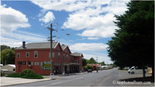
10/ This photo shows the main street. There are many 19th Century houses in Mole Creek.

11/ This is Mole Creek's interesting war memorial. Most Tasmanian towns have a war memorial.

12/ Mole Creek boasts this lovely, Victorian era church.

13/ When you look south from the Mole Creek area, you are presented with many impressive views of the Great Western Tier mountains.

14/ East of Mole Creek is the settlement of Caveside. It boasts this lovely, Victorian era church.

15/ This is the old hall of Caveside. In the distance is the mighty peak of Mother Cummings.

16/ This image shows the pastoral lands near Caveside. In the distance is the mighty peak of Mother Cummings. The photo was taken in the yellow colours of sunset.

17/ This is the lovely, old church of Connorville. It was funded by the nearby Connorville, historic, estate. In the distance is Millers Bluff.

1/ The Alum Cliff is east of Mole Creek in central northern Tasmania. This photo shows that the path to the Alum Cliff is through a regrowth forest.

2/ The hills around the path to Alum Cliff were steep on all sides.

3/ Quamby Bluff is dominant to the east of the Alum Cliff.

4/ On all sides of the path, steep hills surrounded you on the Alum Cliff trail.

5/ This triangle sculpture points to three points: Alum Cliff, Quamby Bluff and Western Bluff.

6/ The view from the Alum Cliff lookout shows the Mersey River surrounded by cliffs. The cliff to the right is where the famous painted layers are.

7/ The famous painted cliffs of Alum Cliff are to the lower right of this photo.

8/ This photo shows a close up of the Mersey River, which are 200 metres below the Alum Cliff lookout.

9/ This shows an orange cliff adjacent to the Alum Cliff.

10/ Western Bluff is about 30 kilometres to the west of the Alum Cliff.

1/ The hamlet of Chudleigh is east of Mole Creek in central northern Tasmania. This photo shows a recently restored historic building, wall and gate at Chudleigh.

2/ The photo shows the building at Chudleigh in profile. Note the green sign in the middle.

3/ The sign has an interesting story to tell.

4/ This gate at Chudleigh shows good workmanship in its restoration. Tasmanian heritage restorers are very skilled in their trade.

5/ This Chudleigh house shows a colonial style.

6/ The general store at Chudleigh is a fine example of colonial architecture.

7/ Chudleigh also has a fine memorial hall.

8/ The honey shop at Chudleigh is well worth a visit.

9/ The shop has a very wide range of honeys and honey products, plus a tasting display.

10/ The shop includes an artistic flight of bees that take you to the honey making display.

11/ The display includes a live bee hive to the left, models in the middle and a video to the right. The honey shop at Chudleigh is an interesting place.

1/ King Solomon's Cave is an interesting, easy to access cave west of Mole Creek. It is just west of the Marakoopa Cave. There are 452 known caves in the Mole Creek area, but only King Solomon's and Marakoopa have easy access for the public. It is only 9 degrees in the cave, so dress to be warm. King Solomon's Cave also only accepts credit cards, as they have had trouble with thieves. This is contrary to the normal rule in Tasmania, where you may often be expected to pay in cash. My other cave photo galleries include: Gunns Plains Cave on the LEVEN CANYON Page and Hastings Cave on the SOUTHPORT information Page.

2/ Accessing King Solomon's Cave includes some stairs and some narrow passages. However, these should be no real problem to a person with normal mobility. The passage shown above is fairly typical.

3/ In this passage you walk between two enormous mineral flow formations. The visitors below should give you some idea as to their actual size.

4/ You can only see the rock formations, because they are artificially lit up. This photo gives you some idea of the darkness that surrounds you. One highlight of our trip was that the guide turned off the lights, at one point, and we were able to eventually see a very soft light coming down from the world above us.

5/ This is a flash photo of the ceiling. Hanging down above us was a forest of stalactites.

6/ Beside the stalactite infested ceiling in this cave were these huge shawl formations.

7/ In this photo you can see a wafer thin shawl formation to the left and a huge column stalagmite to the right.

8/ This huge stalagmite is called a column. It was about a metre wide and about 20 metres high. It was too high for my flash to reach the top. Columns like this take tens of thousands of years to grow to this size. It was one of the special features of King Solomon's Cave.

9/ You can judge the height of this cave from the fence of the path below. The passage opening is about 2 metres high. Note the vast number of features that your eyes try to assess. Entering a cave is truly going into another world. I started to realize why cavers get addicted to their sport of exploring unknown caves.

10/ The ceiling of this cave was noteworthy for its huge stalactites. I estimate that the large stalactites in the centre are about 3 metres in length.

11/ This cave was noteworthy for its huge mineral flows. The device at the bottom measures radiation, which is a slight problem in King Solomon's Cave.

12/ These stalagmites were very large and growing into columns. The one furtherest away is about 4 metres in height. The plethora of shapes that you see in caves makes them very interesting to visit. They are also a special feature of King Solomon's Cave.

13/ This stalactite has become a mineral flow and has grown to be quite large. It was about 5 metres in length and about half a metre wide.

14/ What is intriguing about caves is the large numbers of colors and shapes that you can see in every direction.

15/ I included this photo to show you what the King Solomon's Cave looks like without a flash. There is just blackness punctuated with lit up formations.

16/ This low ceiling included a large number of strange shawl formations.

17/ This photo shows the huge colour range of colours that you see amongst the shawl formations.

18/ There is life in these dark caves. This is a Tasmanian cave spider. The body is about the size of your full thumb and the spread of the legs is larger than the palm of your hand. I did not want to get too close to this monster. The guide at King Solomon's Cave treated him as a pet.

1/ Parsons Track is one of the ancient cattle routes climbing the Great Western Tiers to the Central Highlands. Access is from the hamlet of Chudleigh, where you follow Caveside Road C169 to Fernleigh Road to Parsons Road which leads to the car park and the above sign. Note that the return times are for experienced bushwalkers. The track leads all the way to Lake McKenzie where vehicle access is possible. This is not a route for amateurs.

2/ The track begins as a fire trail. This views looks east to Mother Cummings Peak which is covered in a cloud.

3/ The easy fire trail ends with a bridge.

4/ This view shows the trail to Hills Hut. Note the size of the tree that fell across the track.

5/ This view shows the author at Hills Hut. Very close to this hut is the huge tree shown below.

6/ This view shows the base of the giant tree. It was about 4 meters in diameter. There were once many more of these trees in this part of the Tiers.

7/ This view looks towards the canopy. I estimated that it was about 100 meters tall.

1/ Lobster Falls are in central, northern Tasmania near Mole Creek. Access is from the Mole Creek Road near Chudleigh. The walk is a relatively easy 5 kilometre return with only the last kilometer being rough. The track follows the Lobster Rivulet and passes 3 cascades. This gallery shows the first 2 cascades, as the last is very difficult to reach. This image shows the second cascade.

2/ This image shows the lovely Lobster Rivulet, as it wends its way towards the cascades. The rivulet is named after the giant Tasmanian river lobster that can grow to half a metre in length. The track is mostly in the valley of this rivulet.

3/ On the opposite side of the Lobster Rivulet was this strange formation of rock columns.

4/ This image shows the first cascade. The drop is about 6 metres.

5/ This view looks down on the first cascade.

6/ This image shows the Lobster Rivulet flowing rapidly towards the second cascade.

7/ The rocks on the bank presented some very interesting colours and textures.

8/ This image shows the Lobster Rivulet flowing over the second cascade.

9/ This image shows the roar of the second cascade.

