

.

.


Main photo gallerys are below Information
DEVILS GULLET
Mt Parmeener & Lake McKenzie
SMALL PHOTO & INFORMATION PAGE
DEVILS GULLET is a spectacular valley lookout with a grand view of the mountains to the south. It is a great place from which to appreciate the vast southern highlands of Tasmania. It is easy to access, but there are no facilities at the lookout or nearby. It is located in northern central Tasmania and is about 30 minutes south of the Mole Creek settlement.
It is on a dead end road, so you need to return to B12 near MOLE CREEK to go anywhere else. For this reason you should orient yourself from MOLE CREEK.
From MOLE CREEK you are 15 minutes from, DELORAINE WESTBURY and SHEFFIELD. You are just 30 minutes from Mt JERUSALEM, DEVONPORT, LATROBE, CARRICK and ULVERSTONE. Nearby places are described in NORTH WEST-TARKINE REGION.
View Region Central Mountains of Tasmania in a larger map
FACILITIES: For information telephone (03) 6363 5133 There are no commercial facilities near the Devils Gullet. There is a toilet and a tourist board at the start of the walk. The nearest shopping precinct is at Ulverstone. There is some accommodation at ULVERSTONE.
SIGHT: The Devils Gullet is a spectacular cliff hundreds of metres above the Fisher River Valley. It is a very beautiful place and I am, frankly, surprised that it has the strange name "the Devil's Gullet". An easy 15 minute walks takes you to the lookout, where you see both the 200 metre drop and the mountains beyond the valley. On clear days, you can see all the way to CRADLE MOUNTAIN. You can even see Mt Ossa, the highest mountain in Tasmania.
On windy days you are hit by an unworldly experience as the wind races over the cliffs. On foggy days the view into the mist covered valley is like looking down from Heaven. For these reasons it is a favorite with photographers. Unfortunately, I took my photos on a cloudy day, when the Devils Gullet was not putting on his best colors.
Mt PARMEENER can be reached by following the Parsons Track, which begins at the northern edge of Lake MacKenzie. This begins east of the Yeates Track. Parsons Track is difficult to follow in sections and involves scrambling up rocks. It is only recommended for experience trekkers.
LAKE MACKENZIE is a hydro electric lake, which is popular with fishermen. It is east down the gravel road from the Devils Gullet Lookout. There are 2 tracks on the northern edge of Lake MacKenzie that lead north to near Mt Parmeener.
MIDDLE LAKE is accessed on a track that begins south of the Lake McKenzie Road near the dam. It is suitable only for groups of experienced trekkers.
ROUTE: From MOLE CREEK you drive west towards King Solomons Cave. Just before the cave you turn south onto Mersey Forest Road. You follow this south, until it turns south east into Lake McKenzie Road, which you follow to the Devils Gullet car park. You can continue down Lake McKenzie Road to the Lake McKenzie. AKE
To LARGER DEVILS GULLET PHOTOS
- DEVILS GULLET
- Mt Parmeener
- Lake MacKenzie

1/ The Devils Gullet is in northern central Tasmania south of Mole Creek. From the Devils Gullet lookout you look out upon a vast chasm that stretches 3o kilometres to the South. The peaks of many mountains are visible. Before you is a vast, near vertical cliff.

2/ To the south west of the Devils Gullet, you can see Mt Bran Bluff, which is about 30 kilometres away.

3/ In this close up photo you can see Mt Bran Bluff, on the left, and Cradle Mountain on the right.

4/ This photo shows Mt Fisher Bluff on the extreme left, which is south east of the Devils Gullet lookout.

5/ This photo taken from the Devils Gullet, shows Mount Achilles. This is the strange, pointed peak in the centre of the photo.

6/ This photo taken from the Devils Gullet, shows Mt Pelion West. This is the large, flat topped peak in the centre of the photo.

7/ I took this long format photo to show the extreme 200 metre drop to the south west of the Devils Gullet lookout. At the bottom is a vast scree field.

8/ This photo shows the extreme drop you see when looking towards the south east of the Devils Gullet. At the top left is Mt Fisher Bluff.

9/ This is the scree field at the base of the Devils Gullet lookout. I estimate that the small rocks you can see here are about as large as a car.

1/ Mt Parmeener is in central northern Tasmania. It is south of the town of Mole Creek. This gallery shows photos made on a visit to Mt Parmeener in 2012. This image shows Mt Parmeener in the centre. To its right is Gunns Peak and then Western Bluff.

2/ We approached Mt Parmeener from the north via Parsons Track. This track exits Parsons Road, which exits from Caveside Road, which is south east of Mole Creek. This image shows our first close up view of Mt Parmeener. The summit is 1256 metres high.

3/ This hut on Parsons Track is used as a shelter by bush walkers.

4/ This image shows our walkers entering the dense forest on the edge of Mt Parmeener.

5/ This image shows the regrowth forest at the base of Mt Parmeener. This area has been extensively logged.

6/ One of the first resting points on the walk was Haberle's Hut. It is an ancient shelter built by ancient bush walkers.

7/ Occasionally the forest broke to reveal the panorama around us. This view looks to the west at the edge of Western Bluff and beyond it to a distant Mt Roland.

8/ This enchanting view looks to the north at distant dairy farms engulfed in clouds. In the distance is the Gog Range. This area has some of the best dairy farms in Tasmania.

9/ Our journey was noteworthy for the many beautiful flowers that we saw beside Parsons Track like this beautiful richea.

10/ These colourful flowers were in great profusion.

11/ There are so many wild flowers in the forests of Tasmania that you need to bring a botanist to identify them all.

12/ Towards the summit our walkers had to scramble over bare rock faces.

13/ Water erosion created these interesting patterns in these rocks.

14/ This image was taken near the summit of Mt Parmeener and looks to the east. The first feature is Nells Bluff followed by Mother Cummings Peak. In the distance is Quamby Bluff.

15/ This view was taken near the summit and looks to the north east.

16/ At the top of Mt Parmeener is an alpine plateau. Here you can see our walkers walking towards the highest point.

17/ We lunched on the highest point of Mt Parmeener. This image shows the view to the north. In the distance is the Gog Range.

18/ This view also looks to the north and shows the steepness of the cliffs of Mt Parmeener.

19/ This image shows more of the rugged cliffs that make up the Great Western Tier Mountains.

20/ This view looks to the north west towards Western Bluff.

21/ This view also looks to the north west past Western Bluff towards a distant Mt Roland.

22/ We now began our journey to the south to our exit point This image looks south across the vast plateau that lay before us.

23/ Our party then journeyed some distance to the south on the Parsons Track to a distant Lake MacKenzie. Here you can see a slither of this lake on the horizon.

24/ This image shows a distance Lake MacKenzie from where our group were collected.

1/ Lake McKenzie is a hydro electricity lake in north western Tasmania. It is south of Mt Parmeener and east of the Devils Gullet Lookout. It can be reached from the gravel road to the Devils Gullet Lookout. Lake McKenzie is a popular fishing venue. It also has some interesting native pine forests, plus two tracks leading north beyond Mt Parmeener. This image looks east across Lake McKenzie. Beyond this distant hill is Lake Balmoral. This gallery shows photos taken on a number of separate visits to Lake McKenzie and beyond.

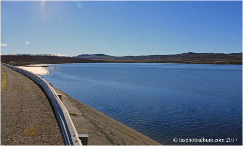
2/ This image of Lake McKenzie shows the same view in the summer of 2017.

3/ This image looks south towards the McKenzie Dam and control tower. Hydro electric dams are rarely full of water.

4/ This is a closer view of the Lake McKenzie control tower.
5/ This is the view from above the dam looking towards the north west. On the middle left is Mr Parmeener. It is the opposite to the view you see in photo number 3.

6/ This view looks north across Lake McKenzie towards Mt Parmeener. Parsons Track begins on the far shore that you can see.

7/ This image looks south east and shows the strange vegetation present in the shallows.

8/ This image shows the rugged south eastern shore of Lake McKenzie.

9/ These two eucalyptus trees balance this view to the south east of Lake McKenzie.

10/ This image looks north towards Mt Parmeener from the northern shore of Lake McKenzie. You can visit Mt Parmeener in the preceding gallery. This image shows the distinct vegetation zones that surround Lake Mckenzie. The most distant zone is a native pine forest. When it is full, the water level reaches up to the pine forest. Parsons Track starts near here and goes north over this mountain to exit on Parsons Road north of the Tiers. Below are some photos taken on Parsons Track.

11/ This image was taken on the road to the Lake McKenzie Dam. It shows the canal, which accesses Lake McKenzie. In the distance you can see Mt Parmeener.

12/ This image was taken on a separate trip on Parsons Track. It shows the edge of the Great Western Tiers and the rich northern coastal plain as seen from near Mt Parmeener. The distant mountain in the centre is Quamby Bluff.

13/ This image shows a flooded area opposite Parsons Track.

14/ We also saw ancient pencil pines, as we approached Mt Parmeener on Parsons Track.

15/ These exotic plants are cushion plants. They only grow in wet places.

16/ These next photos were taken on a separate trip from Lake McKenzie south to Middle Lake. The track to Middle Lake exits from the Lake McKenzie Road south west of the dam. This journey passed through a variety of landscapes. Here you can see a lovely tarn. There are still patches of snow nearby even though this photo was taken in the summer.

17/ This tarn near Middle Lake is in alpine vegetation. Beyond is a eucalyptus forest.

18/ Middle Lake had both native pines and pencil pines on its shores.

19/ Middle Lake had some strange shapes and contrasts. There is a deep serenity about Tasmania's alpine lakes and tarns.

20/ This photo shows the typical terrain that we passed through near Middle Lake. Sparse grasses interspersed with groves of native pines, plus cushion plants and glacial boulders.

21/ This is the road to Lake McKenzie. It was taken in the summer of 2017. There had been a snow drop on the night before we came. Travellers must know that it still frequently snows even in the summer in Tasmania.

22/ This was our view as we returned from Lake McKenzie. It looks to the north west. On the left is Mt Emmett and beyond it is Barn Bluff. To the right is Cradle Mountain. You can see more photos of both Barn Bluff and Cradle Mountain on other pages.

23/ This is the view from the Fisher River Lookout on the road to Lake McKenzie. From left to right are: Mount Massif, Mt Ossa, Mt Achilles and Mt Pelion West. These are the mountains seen by trekkers on the famous Overland Track.

24/ This image shows Clumner Bluff, which is near the Devils Gullet. To the right are the mountains seen in the image above.

