

.

.


Main photo gallerys are below Information.
ANSONS BAY & Eddystone LH
SMALL PHOTO & INFORMATION PAGE
ANSONS BAY is a boating and beach settlement in the extreme north east of Tasmania. Just north of Ansons Bay is the famous EDDYSTONE Lighthouse with its historic lighthouse and beautiful dunes and beaches. Ansons Bay is part of the famous BAY of FIRES. It is a great place to relax in, but, unfortunately, there are no regular facilities in this area.
EDDYSTONE Lighthouse is on the southern edge of the Mt WILLIAM National Park, which is replete with wildlife. This area is the northern edge of the famous beaches of the Bay of Fires.
From the hamlet at Ansons Bay you are 30 minutes from GLADSTONE, the nearest town, and from MUSSELROE BAY. You are 50 minutes from DERBY and the WATERHOUSE beach. Nearby places are described in the NORTH EAST REGION page.
View Region North East in a larger map. Unfortunately, you need to go to the Google Page 2 map to see some of my marked features.
FACILITIES: There are no commercial facilities at Ansons Bay. The nearest are at GLADSTONE. The nearest significant town is DERBY. There is some accommodation near ANSONS BAY.
TOURIST information telephone (03) 6392 2211 or contact www.bayoffires.com.au
SIGHTS: Ansons Bay is an inlet bordering on the beautiful, white beaches of the Bay of Fires. Both to the north and south of Ansons Bay are beautiful, long, deserted, white sand beaches, so its a great place to go to relax and escape. The bay is used by small boats enjoying the Bay of Fires area.
-
EDDYSTONE Lighthouse is just north of the Ansons Bay hamlet. This lighthouse was built in 1889 and is one of the largest in Australia. The keeper's house is open for inspection. At Eddystone you are at the most easterly point in Tasmania. There is also a beautiful beach at Eddystone.
-
Mt WILLIAM National Park has abundant wildlife including; dozens of bird species, as well as kangaroos, wallabies, pademelons, echidnas, possums and devils.
-
BAY of FIRES Walk starts at the Bay of Fires Lodge and goes passed Eddystone Lighthouse to ANSONS BAY.
ROUTES: From the NORTH EAST coast you approach ANSONS BAY by driving east on B82 to the small town of GLADSTONE. You then drive east on C843, which is a gravel road. This road diverges into two roads. You turn south east onto C843 to access ANSONS BAY and the EDDYSTONE Lighthouse. POLICEMANS Point is accessed from a gravel road south of the Ansons Bay settlement.
The other road at the junction of C845 is the gravel road that takes you to the GREAT MUSSELROE hamlet. You can follow C843 all the way south to St HELENS, but the route is quite rough.
WARNING: The rough gravel roads in the Mt William National Park are not recommended for large vehicles. All vehicles are also warned that at sunset the roads are used by animals as pathways, so you must drive very carefully.
To LARGER ANSONS BAY PHOTOS
- ANSONS BAY
- EDDYSTONE Lighthouse
- Bay of Fires

1/ Ansons Bay is on the extreme north east coast of Tasmania. It is a large hamlet serving pleasure boating and beach activities. There is also a large camping area at nearby Policemans Point.

2/ Ansons Bay is a large enclosed bay with only a narrow exit into the Tasman Sea. The western shore is dotted with holiday homes.

3/ Ansons Bay has a number of piers and places to launch boats. It is very busy in the summer holidays.

4/ This is a lagoon near the Ansons Bay hamlet.

5/ This is the view from Policemans Point looking West towards the Ansons Bay hamlet.

6/ The entrance to Ansons Bay is via a narrow entrance that can only be crossed by boats at high tide.

7/ Looking north across the bar you can see Eddystone Lighthouse 10 kilometres away.

8/ At Policemans Point you look south across the famous Bay of Fires. At high tide the mighty Tasman Sea crashes into the shore.

9/ The approach to Ansons Bay is through very fertile farm land. In the distance is Mt Cameron.

10/ I was lucky that day to snap this lovely photo of a rainbow near a dairy farm near Ansons Bay.

1/ Eddystone Lighthouse is about 10 kilometres north of Ansons Bay. It is on the most eastern edge of Tasmania. The lighthouse is 42 metres high and was built in 1889. Its light can be seen from 40 kilometres away.

2/ This is the base view of the Eddystone Lighthouse.

3/ From Eddystone Lighthouse you look north across a rocky shore. To the left is the Mt William National Park.

4/ Near the Eddystone lighthouse is the original light house that was replaced by the massive tower in 1889.

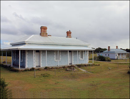
5/ Near Eddystone lighthouse were three quaint homes for the lighthouse keepers families.

6/ This metal shed was probably the first building built on the Eddystone lighthouse site.

7/ South of the lighthouse is Eddystone Beach. This is the start of the famous Bay of Fires beach. This is truly one of the most beautiful beaches in the World.

8/ To reach Eddystone Beach you must cross through a large area of beautiful white sand dunes.

9/ The dune valleys at Eddystone Beach are so deep in places that you can not see the sea beyond.

10/ The Bay of Fires has many moods. Here you see two plovers feeding near the surf.

11/ The roar of the waves dominates the beach at Eddystone. It is truly a very beautiful and peaceful place.

12/ The shore line near Eddystone Lighthouse is replete with boulders sculptured by the wind.

13/ This large boulder was twice the height of a man.

14/ This is a cove North of Eddystone lighthouse. Beyond is the Mt William National Park.

15/ The Bay of Fires beaches are famous for their red stained rocks.

1/ The Bay of Fires is a large beach conservation area in north east Tasmania. It stretches from Ansons Bay south to St Helens. This page shows photos taken in the Gardens area in 2014. This area is accessed from "Gardens Road" which starts just south of Binalong Bay.

2/ The walks starts on a lovely white sand beach. Note that many beaches in Tasmania have dangerous rips and you should find out about their safety before bathing. Do not expect to see signs warning you that your beach is dangerous.

3/ The beach is narrow at this point.

4/ A large creek exiting into the Bay of Fires. You should expect to have to cross small creeks on your way.

5/ This photo shows a small creek emptying into the bay.

6/ This photo shows a large tibal pond.

7/ This photo shows how you will meet areas of shingle, sea weed as well as sand.

8/ In some sections you will have to walk on scree.

9/ The relentless sea is always to be seen and heard.

10/ Pelicans forage on a sand bar.

11/ A view down towards grass and red rocks.

12/ At this point we were crossing red rocks. On the horizon is one of the many hamlets that are close to the Bay of Fires.

13/ This photo shows a close up of the famous red rocks.

